Author: DiveSpots
-

East Fourteen/Gator Bowl
Fast Facts: Features: Need Gear? Download all Jacksonville GPS Coordinates This area contains over a dozen reefs including Red Rock Reef and Y-Ledge. The most popular portion of this area is the Gator Bowl Press Boxes. The original Gator Bowl stadium was torn down to build a new stadium for the Jacksonville Jaguars. Debris from…
-
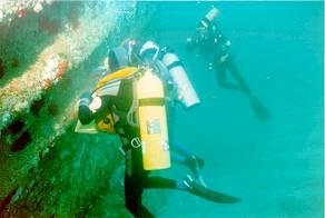
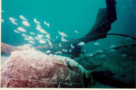
Coppedge Tug
Fast Facts: Features: Need Gear? Download all Jacksonville GPS Coordinates This 103-foot tug was sunk in 1988 and remains intact and upright. The artificial reef now draws an impressive amount of sea life. The schools of baitfish are so dense that it is often hard to see the wreck upon first arrival. The tug rests…
-
Clayton’s Holler
Fast Facts: Features: Need Gear? Download all Jacksonville GPS Coordinates The most popular dive spot in the Jacksonville area is Clayton Holler. This area of reefs and ledges lies 16.7 miles from the Mayport jetties. There are three reef spots with several ledges. One of the ledges that is part of the northern group contains…
-
Blackmar’s Reef
Fast Facts: Features: Need Gear? Download all Jacksonville GPS Coordinates Blackmar’s Reef is composed of five large wrecks, two airplanes, and some small natural reefs. Among these wrecks, the three largest, the “Warwick”, the “Ocean Going Tug,” and the “Super ” all draw spear fishermen who are attracted to the schools of spadefish and amberjacks…
-
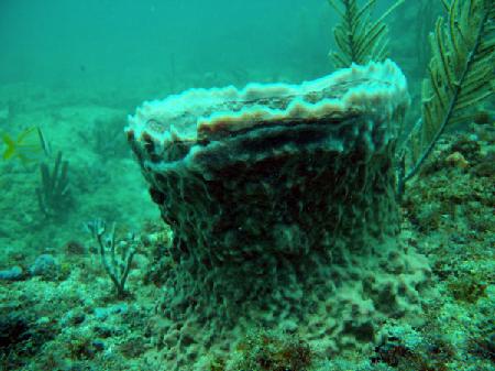
Amberjack Hole
Fast Facts: Features: Need Gear? Download all Jacksonville GPS Coordinates This is one of the most alive and magnificent artificial reefs in the Jacksonville area. A ten-foot ledge dominates the reef providing protection for marine creatures and anchoring the soft corals and sponges. The namesake amberjack are normally seen swimming through the area in large…
-
Acosta Bridge Rubble
Fast Facts: Features: Need Gear? Download all Jacksonville GPS Coordinates The Acosta Bridge once spanned the St. Johns River, but now lies 75 feet underwater, 12.4 nautical miles from the Mayport Jetties. Six barges were used to transport the concrete rubble that was placed off shore in 1992 to form an artificial reef. Two barges…
-
Union Express
Fast Facts: Features: Need Gear? Download all Fort Lauderdale GPS Coordinates The 170-foot Union Express was sunk in 1992 to foster the formation of an artificial reef. This site was originally named the Mariner Outboard/Pompano Rodeo Artificial Reef, and is located 1.5 miles due east of the Pompano Pier. The Union Express was confiscated by…
-
The Caves / Twin Ledges Moorings
Fast Facts: Features: Need Gear? Download all Fort Lauderdale GPS Coordinates A shallow series of ledges located about 2 miles north from the Port Everglades Inlet. A system of 16 moorings mark a broken ledge varying in depth from 20 to 30 feet. This area makes for an easy second after visting the deeper nearby…
-
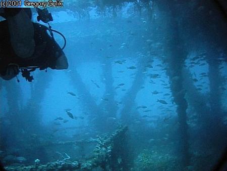
Tenneco Towers
Fast Facts: Features: Need Gear? Download all Fort Lauderdale GPS Coordinates Tenneco Towers, the largest artificial reef in southeast Florida, was created in 1985 when the Tenneco Oil Company sank five large sections of oil production platforms. The decommissioned oil platforms were transported by barge and sunk in a straight east-west line, each a little…
-
Spotfin Reef
Fast Facts: Features: Need Gear? Download all Fort Lauderdale GPS Coordinates Spotfin Reef lies 1.25 miles northeast of the Port Everglades Inlet. This natural reef contains a ledge which begins at 50 feet and drops to a sandy bottom at 65 feet. The ledge has many crevices and caves which protect sea life. Many varieties…