Author: DiveSpots
-

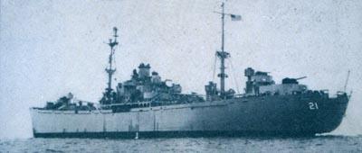
Zane Grey
Fast Facts: Features: Need Gear? Download all Nags Head / Oregon Inlet GPS Coordinates The Zane Grey is one of many Liberty Ships from World War II that have been deployed in artificial reef programs. The Liberty Ships were generally all about 440-feet in length and made of pre-fabricated materials. The ships were quickly assembled…
-
Dionysus
Fast Facts: Features: Need Gear? Download all Nags Head / Oregon Inlet GPS Coordinates This Liberty ship was built in Baltimore, Maryland and was originally named Faithful. The plan was to transfer the ship to the British Royal Navy, but she was retained by the United States Navy and renamed Dionysus. Dionysus served during the…
-
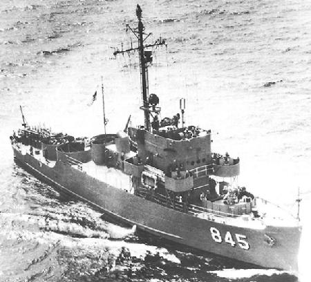
Advance II
Fast Facts: Features: Need Gear? Download all Nags Head / Oregon Inlet GPS Coordinates The Advance II was laid down in July 1943 as a Patrol Craft Escort (PCE-845). She was commissioned in March 1944 and in April sailed from Miami, Florida to Port-of-Spain, Trinidad. The ship escorted coastal convoys from Port-of-Spain to Brazilian ports.…
-
Rabbit’s Lair
Fast Facts: Features: Need Gear? Download all Jacksonville GPS Coordinates Just over 13 nautical miles from the Mayport jetties, are several long ledges known as the Rabbit’s Lair. Depths in this area average 70 feet with some ledges reaching up 10 feet from the bottom. The natural ledge structure generally runs north to south with…
-
Paul Main’s Reef
Fast Facts: Features: Need Gear? Download all Jacksonville GPS Coordinates Paul Main’s Reef can be found ten miles off Jacksonville Beach or 10.6 nautical miles from the jetties. The The Paul Mains Tug sits upright in a featureless sand flat with a slight list to port. The tug depths range from 45 feet atop the…
-
Nine Mile Reef
Fast Facts: Features: Need Gear? Download all Jacksonville GPS Coordinates Nine Mile Reef, located 10.4 nautical miles from the Mayport jetties, contains several wrecks. The most popular are Open-Sided Barge, Vic’s Barge, Asphalt Barge, and a 52-foot steamer tug. There is also a fishing boat, which was sunk in 1988. Grouper averaging 15 pounds, along…
-
Montgomery’s Reef
Fast Facts: Features: Need Gear? Download all Jacksonville GPS Coordinates This is a popular site for spear fishermen, particularly near the 63-foot tug Reliance, Culvert Reef and Thunderdome. The reef area consists of over one dozen shipwrecks including a 120-foot barge and an upside-down barge. Depths are generally around 65 feet on these wrecks although…
-
Middle Ground
Fast Facts: Features: Need Gear? Download all Jacksonville GPS Coordinates Middle Ground consists of a series of small reefs and can be found 13.5 nautical miles from the Mayport jetties. The area contains two artificial reefs which have become popular. A steel tug 85 feet down has fostered the formation of a variety of soft…
-
Hudgins
Fast Facts: Features: Need Gear? Download all Jacksonville GPS Coordinates The Hudgins, a 150-foot freighter, was sunk to foster the formation of an artificial reef in 1987. She lies intact and upright in 105 feet of water. Little Wreck, an old barge, is located nearby and 90 feet down. Another barge and small reefs are…
-
Freighter Anna Artificial Reef
Fast Facts: Features: Need Gear? Download all Jacksonville GPS Coordinates The Anna, a 225-foot freighter, was reefed in 1986 off the coast of Jacksonville. She lies on her starboard side in 110 feet of water. She once served the shipyards of Scotland and ran supplies during World War II. In 1981 she was confiscated for…