Author: DiveSpots
-
DEMA Trader
Fast Facts: Features: Need Gear? Download all Miami GPS Coordinates The DEMA Trader (formerly known as the GGD Trader) is a 165-foot-long freighter in 80 feet of water about 3 1/2 miles off Key Biscayne. The ship was seized by U.S. Customs for carrying drugs, and was renamed DEMA Trader after the Dive Equipment and…
-

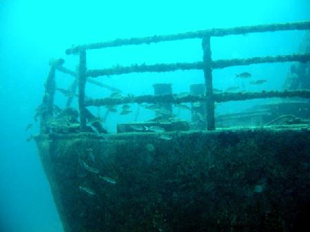
Deep Freeze
Fast Facts: Features: Need Gear? Download all Miami GPS Coordinates The Deep Freeze — now one of Miami’s most popular advanced dive sites — was a 210′ freighter sunk in 135′ of water in October 1976. She had a 33.5′ beam and displaced 1,138 gross tons of water. Her top deck can be reached at…
-
Customs Reef
Fast Facts: Features: Need Gear? Download all Miami GPS Coordinates The US Customs Reef is located four miles east of Key Biscayne and contains four cargo ships. These ships include the Bradywine, Minguana, Etoile de Mer, and Tacoma which were all sunk in 2001. The Tacoma was not one of the initial ships sunk to…
-
C-One
Fast Facts: Features: Need Gear? Download all Miami GPS Coordinates Built in the early 1940s and originally named Christina, this U.S. Navy steel tug was purchased by the Department of Environmental Resources and prepared for sinking in 1990. The engines, portholes and hatches were removed and on October 27th, the tugboat, Captain Donald, began to…
-
Concepcion
Fast Facts: Features: Need Gear? Download all Miami GPS Coordinates While anchored off Miami Beach in February of 1991, this Honduran freighter was pummeled by heavy winds and rough seas until it broke anchor and ran aground just offshore of South Beach. After months of court battles, and rigorous cleaning to the tune of over…
-
Blue Fire
Fast Facts: Features: Need Gear? Download all Miami GPS Coordinates This 175-foot passenger freight was sunk in 1983 and is filled with sea life. The Blue Fire was seized during the Cuban exodus by the Coast Guard. Today, she is located South of Miami and is home to many larger fish such as jacks, snapper,…
-
Biscayne Freighter
Fast Facts: Features: Need Gear? Download all Miami GPS Coordinates The Biscayne Wreck is located 4.5 miles east of Key Biscayne and was a well-kept fisherman’s secret from 1974 to 1980. This 120-foot ship was often referred to as the “Banana Freighter” because it was used to transport bananas between the Caribbean Islands and from…
-
Billy’s Barge
Fast Facts: Features: Need Gear? Download all Miami GPS Coordinates The Anchorage Artificial Reef site includes several barges, ships, and concrete structures in close proximity to each other. Two Army tanks are also in the Anchorage. Billy’s Barge is 110 feet in length and sits in just 50 feet of water. It is surrounded by…
-
Belzona Triangle
Fast Facts: Features: Need Gear? Download all Miami GPS Coordinates East of Belcher Barge, in the Key Biscayne Artificial Reef Site lay three ships, Belzone One, Two, and Three. This trio lies in a triangular shape. Belzona One is an 85-foot tug boat which was used throughout the Bahamas before she was harmed by a…
-
Bache Shoal
Fast Facts: Features: Need Gear? Download all Miami GPS Coordinates A popular shallow patch reef just east of Sands Cut and Elliott Key. The reef is marked by 3 mooring buoys and is no more than 15 feet deep. Many of the boulder and brain corals are no more than 5 feet below the surface.…