Author: DiveSpots
-
Lugano
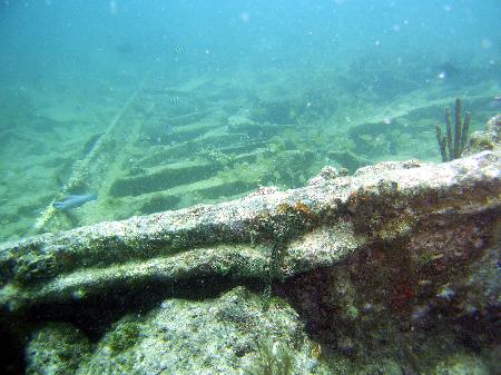
Fast Facts: Features: Need Gear? Download all Miami GPS Coordinates The Lugano was a 350-foot single screw, iron-hulled British steamer with a 40-foot beam. Built in 1882 by the Barrow Shipbuilding Company, she originally sailed under the name Navarro. In 1897, the Navarro underwent a major overhaul and was renamed Lugano. On the afternoon of…
-
Long Reef
Fast Facts: Features: Need Gear? Download all Miami GPS Coordinates Long Reef, so named for the large reef area running south for two miles, has many great diving opportunities. The reef system runs almost parallel to Elliot Key, lying just east of it and south of Triumph Reef. You can find almost all kinds of…
-
Jose Cuervo
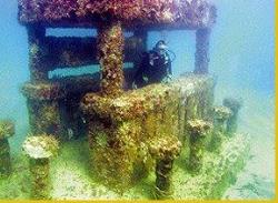
Fast Facts: Features: Need Gear? Download all Miami GPS Coordinates Located in the South Beach Artificial Reef Site, approximately 150 yards southeast of the Second Street lifeguard station on Miami Beach, this 22-ton concrete margarita bar was sunk on May 5th, 2000 during Ocean Realm Splash, nicknamed ‘Sinko De Mayo.’ Designed with a dive flag…
-
Half Moon Preserve
Fast Facts: Features: Need Gear? Download all Miami GPS Coordinates The Half Moon was built in Germany in 1908 as the Germania. It was one of the fastest racing yachts of its day and won the German Kaiser’s Cup. The Germania had the misfortune to be in England for a race when World War I…
-
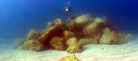
Golden Beach Boulder Reef
Fast Facts: Features: Need Gear? Download all Miami GPS Coordinates On January 10, 2005, the Golden Beach Artificial Reef Site was inaugurated with the deployment of approximately 850 tons of limestone boulders. The Florida Fish and Wildlife Conservation Commission Division of Marine Fisheries provided an artificial reef construction grant to cost-share the creation of Miami-Dade…
-
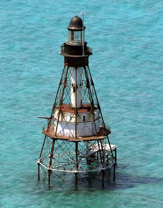
Fowey Lighthouse / Fowey Rocks
Fast Facts: Features: Need Gear? Download all Miami GPS Coordinates The Fowey Ligthouse is hard to miss as you head out into open waters through beautiful Stiltsville and the Biscayne Channel. As you head out of the channel towards open water, head directly SE after passing marker #1. You’ll see the lighthouse just pass “Bug Light”. Under…
-

Esjoo
Fast Facts: Features: Need Gear? Download all Miami GPS Coordinates The 70 foot Haitian freighter Esjoo was sunk as an artificial reef and sits in 50 feet of water. ** NOT SURE ABOUT GPS COORDINATES ** Waypoint: ESJOO Latitude Longitude Degrees 25.81315 -80.0895333333333 Degrees/Minutes N 25 48.789 W 80 5.372 Degrees/Minutes/Seconds N 25 48 47.340…
-
Erl King
Fast Facts: Features: Need Gear? Download all Miami GPS Coordinates The vessel Erl King was a 305-foot three-masted, single screw, iron auxiliary steamer with a 34-foot beam. Built in 1865 by A. and J. Inglis Shipbuilders, the steamer displaced 2,180 tons. On December 16, 1891, The Erl King ran aground on Long Reef during a…
-
Emerald Reef
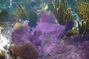
Fast Facts: Features: Need Gear? Download all Miami GPS Coordinates Emerald Reef is a small shallow-water patch reef one mile east of Key Biscayne. It’s considered by many to be one of the most beautiful reefs in Miami, rivaling those found further south in the Florida Keys. The reefs are in 10 to 20 feet…
-
Doc DeMilly Memorial Reef
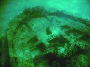
Fast Facts: Features: Need Gear? Download all Miami GPS Coordinates This 287-foot steel freighter is located 150 feet down underwater and just mile east of the Pacific Reef Lighthouse. This vessel was built in 1949 and renamed for a local veterinarian and pioneer before it was sunk in 1986. The interesting thing about this sinking…