Author: DiveSpots
-
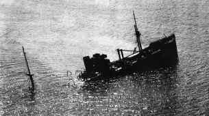
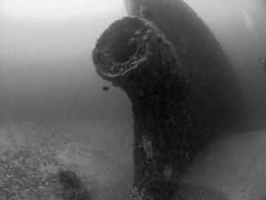
Benwood Wreck
Fast Facts: Features: Need Gear? Download all Key Largo GPS Coordinates Located within the Florida Keys National Marine Sanctuary is the Benwood. This 285-foot 1910 English-built ship sailed a crew of 38 with 12 rifles and one four-inch gun. The actual sinking of the Benwood, which occurred in 1942, has been a subject of much…
-

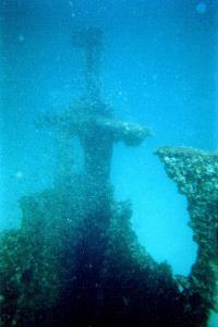
Tarpon
Fast Facts: Features: Need Gear? Download all Panama City GPS Coordinates This twin-screw steamer powered by twin compound engines was built in 1887 in Wilmington, Delaware and launched as the Naugatuck. She had an iron hull, was 130 feet in length and had a 26-foot beam. In 1889 she was sold to Henry B. Plant…
-

Spanish Shanty Barge
Fast Facts: Features: Need Gear? Download all Panama City GPS Coordinates This 150 foot long old tar barge sits in 20 feet of water on the northwest corner of Shell Island inside St. Andrews Bay near the Spanish Shanty cove (hence the wreck’s name). She holds a good assortment of marine life including sheepshead, banded…
-
Leroy
Fast Facts: Features: Need Gear? Download all Panama City GPS Coordinates This ship was originally named the United States Revenue Cutter Samuel Dexter and was built in Boston in 1874. She was 144 feet long, had a 23-foot beam and two masts with topsail rigs. She also had a 400-horsepower compound engine. Revenue cutters originated…
-
E. E. Simpson Tug
Fast Facts: Features: Need Gear? Download all Panama City GPS Coordinates The tugboat, E. E. Simpson was built in Philadelphia in 1877 and named in honor of the founder of the E. E. Simpson Bank of Pensacola. The tug was 93 feet in length, with a 20-foot beam. The Simpson was frequently seen chugging up…
-
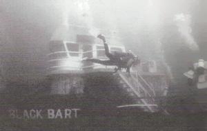
Black Bart
Fast Facts: Features: Need Gear? Download all Panama City GPS Coordinates This artificial reef is named “Black Bart” in memorial to Captain Charles Bartholomew who was the Navy’s Supervisor of Salvage in Panama City for many years. Capt. Bart was an avid sport diver who worked diligently on many joint artificial reefs between the Navy…
-
Benjamin H. Grierson (Liberty Ship)
Fast Facts: Features: Need Gear? Download all Panama City GPS Coordinates The Benjamin H. Grierson is one of many Liberty Ships that were quickly built around the U.S. during World War II. The Grierson was built in 1943 by the Oregon Ship Building Corporation in Portland, Oregon. Many Liberty Ships were named for officers of…
-
Thomas Hayward (Liberty Ship)
Fast Facts: Features: Need Gear? Download all Destin GPS Coordinates Designed to serve as an emergency cargo ship for the U.S. Maritime Commission, the 360 foot Liberty Ship, Thomas Hayward, was built by the Alabama Drydock Company in 1942. On May 5, 1946, the ship hit a floating mine off Europe. Despite the damage, the…
-
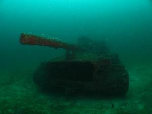
The Tanks
Fast Facts: Features: Need Gear? Download all Destin GPS Coordinates As part of the Okaloosa County Artificial Reef Program, fourteen United States Armored M-60 tanks were placed underwater in December 1994. The tanks were sunk in three sets at depths ranging from 65-70 feet. The tanks are all intact, making this divespot a great site…
-
Mohawk Chief / Sand Dollar Artificial Reef
Fast Facts: Features: Need Gear? Download all Destin GPS Coordinates Okaloosa County and the cities of Destin and Valparaiso teamed up to create a Sand Dollar Artificial Reef Complex in 2003. The complex is a set of six patch reefs arranged about 800 feet apart in a hexagonal shape around a center point. The center…